
The Moon represents an incredible archive of the early history of the inner Solar System, a several billion years period that included the stabilization of Earth into a world capable of sustaining life. We may never fully understand the evolution of environmental conditions in the inner Solar System that eventually led to the origin of life on Earth, without a more comprehensive understanding of the in-depth history of our nearest neighbor.
The Geological Side of the Moon
Geology is a discipline of Earth Science that focuses on the studies of rocks and sediments, including their composition, possible deformation due to tectonic processes, and all the morphological characteristics related to long-lasting natural processes that allows the experts to infer the overall geological history. Similar study approaches can be applied to any terrestrial planetary body, satellite, or small body of the solar system, so one can consider the geology of Venus, the Moon, a comet nucleus, and so on.
The extraterrestrial geologic materials, depending on body size and position in the solar system, range from silicate rocks, sulfates, basalts, ices, and organic materials (in the sense of chemical composition), meteorites (asteroidal, lunar, and Martian, plus possibly cometary) stones, stony-irons, and irons, micrometeorites (asteroidal and cometary), to products of their surface destruction by a set of processes (e.g. aeolian erosion and subsequent deposition of the eroded gains).
Differences between planetary geology and the geology of Earth have been observed. Such differences are due to their connected but unique geological evolutions under different conditions. Since its formation, the Moon has undergone a simple evolution in reducing, low-oxygen, and vacuum conditions with an apparent lack of plate tectonics.
The Moon hasn’t changed much in the last 3.3 billion years whereas the Earth has a dynamic surface with tectonics, atmosphere, life, etc. In addition, there is a low level of understanding of lunar geology because it is being studied mostly by remote sensing and by rare landing missions with even rarer sample returns (supported by geophysical and geochemical modeling).
Geologic study of any body and its parts implies the investigation of changes and variations in time that demand measurements of time. On Earth, one can determine the age of rocks and fossils using radioactive isotopes to get an absolute age.
Off-Earth, we have dated returned rock samples from the Moon with the same methods. Without samples, we can only use relative dating methods. One of the most commonly used is crater counting, measurements of spatial density of impact craters superposed on various geological units. These ages are calibrated with the known age and origin of dated Moon rocks.
Earth’s Moon
The Moon is a satellite of Earth, orbiting it at a distance of 384,400 km. Its orbital period is 27.3 Earth days and its rotation period is the same. The rotation period of the Moon is not the lunar solar day. Because the Moon together with Earth moves around the Sun, the combination of this movement and the around-axis rotation makes the solar day on the Moon. This makes the lunar day period half of 27.3 which is about 13.5 Earth days (as with night dark periods). It takes 29.5 Earth days to go from a new moon-full moon-new moon cycle visible from Earth (relative positions of the Moon, Earth, and Sun – synodic month). The time it takes to orbit the Earth and rotate on its axis (sidereal month/lunar day). The long solar day results in a high surface temperature (up to 120 C/248 F). But the Moon has no atmosphere so during its long night the temperature may drop down to -150 C/-238 F. In extreme environments like in the shadowed craters it can go as low as -230 C/-382 F.
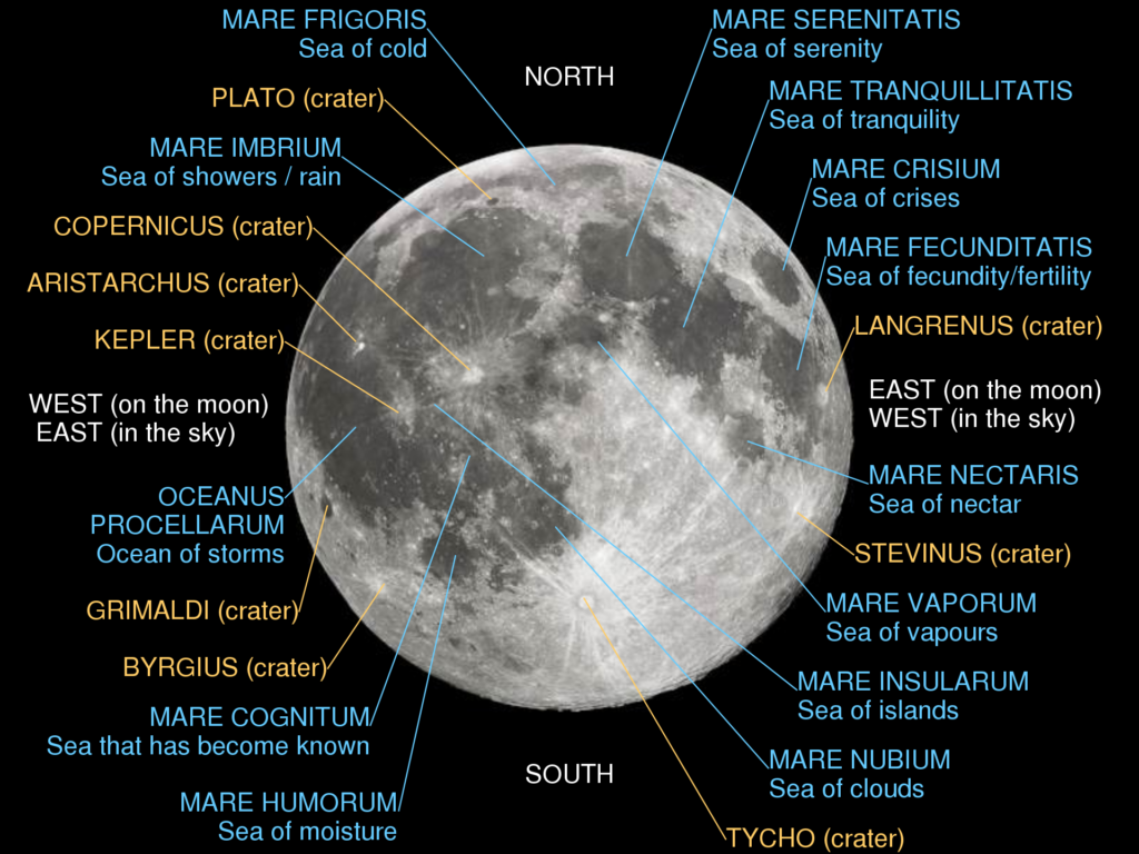
Because the Moon’s orbital period and its rotation period are the same the Moon always looks at Earth from the same side; thus in descriptions of the Moon, the terms near side (visible from Earth) and far side (invisible from Earth) of the Moon are often used. About 1/3 of the near side is covered by relatively dark basaltic plains called maria (single mare – English “sea”) and the dominant lunar terrain consists of heavily cratered highlands. On the far side of the Moon mare surfaces are rare and cratered highlands predominate. So in total lunar maria occupy ~17% of the lunar surface.
The Moon is a differentiated body. It has a geochemically distinct crust, mantle, and core. The core with a radius of 300 km is iron-rich and may be partly molten, i.e. liquefied by heat. The mantle is composed of ultramafic rocks (also called ultrabasic rocks; magnesium-rich silicate rocks). Whereas the crust consists of anorthositic rocks (Ca-rich silicate rock consisting dominantly of the association of minerals anorthite–plagioclase).
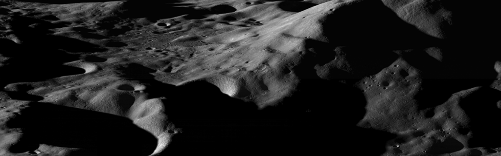
The surface of the Moon is ancient, it is estimated that 99% of the lunar surface is older than 3 billion years, and more than 80% is older than 4 billion years. In contrast, more than 80% of the Earth’s surface is younger than 200 million years. Impact craters dominate much of the lunar surface and the Moon has provided us with much knowledge about impact cratering as a geological process. The major process modifying the lunar surface (we can consider it a form of erosion) is impact, ranging from micrometer-sized grains to asteroid-sized objects. These many impacts created the lunar regolith, a layer of debris that covers the surface. The material in the regolith ranges from dust to blocks several meters across.
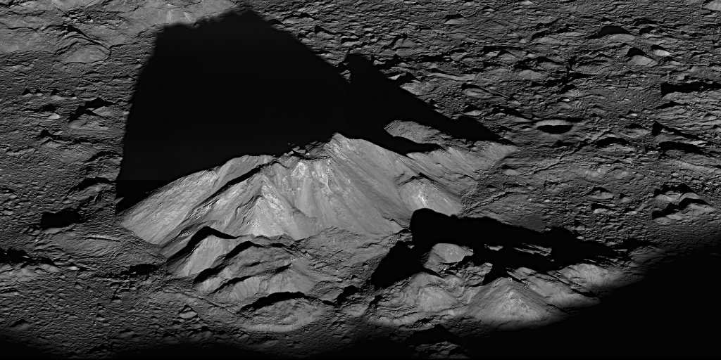
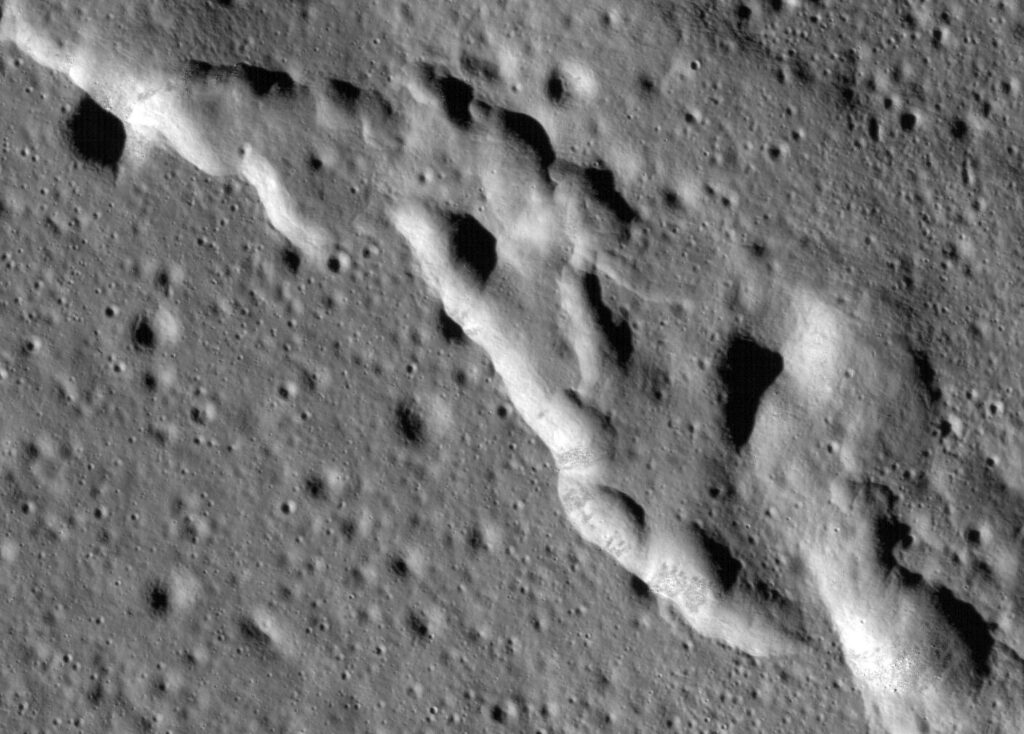
The average thickness of the regolith is 4-5 m over the maria (i.e. extensive dark basaltic plains) and about 10 m over the highlands. The Moon has no large plate tectonic features, though there are tectonic features related to stresses associated with the subsidence of the mare basins after they were flooded by lavas. Wrinkle ridges (also called mare ridges) are low-relief, linear to arcuate, broad ridges that tend to form near the edges of maria.
Credits: NASA
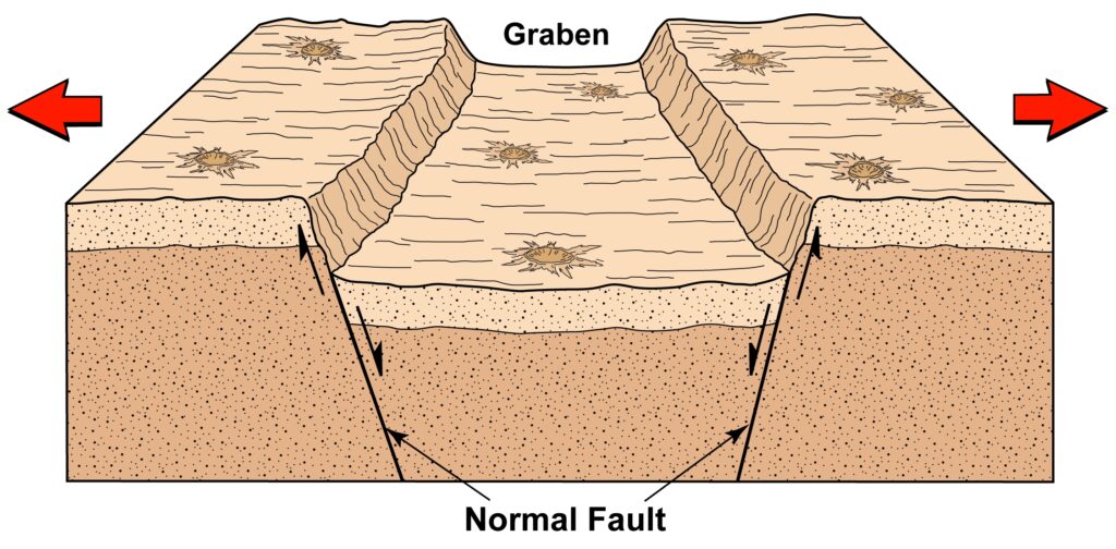
They are the result of compressional bending stresses, related to the subsidence of the mare basalts from cooling. Some extensional stresses existed on the Moon prior to about 3.6 billion years ago. Rilles, which are similar to terrestrial graben (i.e. an elongated block of the Earth’s crust, bounded by faults, that has dropped relative to the surrounding area), are found cutting the older maria and highlands.
Credits: Arizona State University/Smithsonian Institution
Note that Hadley Rille (also referred to as Rima Hadley) and other sinuous channels (called sinuous rilles) in the maria were not formed by tectonic stresses, but by thermal erosion of flowing lava. They are formed as the result of surface lava flows or collapsed lava tubes. Planetary geologists are now tending to refer to tectonic lunar rilles as graben to avoid confusion.
Beginning of the Moon’s Geological Exploration
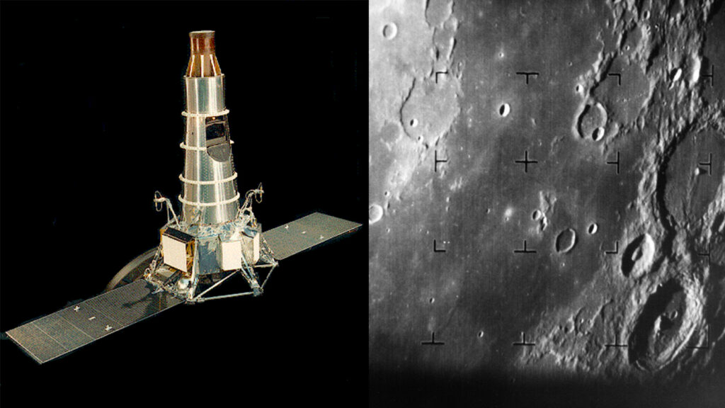
The modern exploration of the Moon started around 1959, with the first attempts by the Soviets to send space probes there. Two probes missed the target, but Luna 3 made the first pictures of the dark side of the Moon. On 3 February 1966, Luna 9 made it safely to the surface, sending the first pictures from there. The images showed an extremely rugged terrain, the terrain was interpreted as a lava field, causing quite some concerns. If the Moon was covered everywhere by lava, a hard rock with sometimes sharp edges, landing a manned spaceship there would be extremely dangerous. Only later it was discovered, that the image was distorted due to an error in decoding the radio signal. At the time most scientists imagined the Moon to be a very strange, alien landscape. Mountains, not constrained by gravity as on Earth, were imagined to be extremely high and with steep slopes. In fact, some mountains found on the Moon, rise above the surrounding terrain by more than 10,000 feet. The mountains and crater rims are also visible during a solar eclipse, as sort of rugged shadows, a phenomenon known as Baily’s Beads.
Credit: NASA/GSFC/Arizona State University
Source: NASA/GSFC/Arizona State University
To assure the safety of manned (or nowadays, personed) exploration, it was necessary to know in detail the terrain and the composition of the lunar surface. A photogeologic survey was initiated. From 1966 to 1968 Soviet space probes in orbit around the Moon mapped its surface. Between 1959 and 1964 the Americans initiated the Ranger program, followed by the Lunar Orbiter, dedicated to the same goal. The Surveyor project also included some probes landing on the Moon. The surveys showed that there were also fairly soft and rolling terrains, where a spaceship could safely land.
Credits: NASA/JPL-Caltech
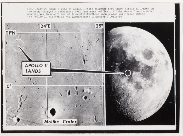
July 20, 1969, with the first steps in the Sea of Tranquility, a mare on the Moon, during the Apollo 11 mission, the crew of the Eagle, Neil Armstrong and Edwin Aldrin, also geologized there. Both had trained in geologic fieldwork on sites like Barringer Crater, the Grand Canyon in Arizona, Valles Caldera in New Mexico, Marathon Basin, and Big Bend Park in Texas.
Source: ICP
Lunar Rocks
The Moon is not a uniform, homogeneous planet. It consists of different rocks, formed in different ways at different times. Some of the Moon’s rocks are familiar. The basalt lava flows that cover the dark maria formed in the same way as many of the lava flows on Earth – by melting deep in the planet, followed by an ascent of molten rock to the surface and eruption through fractures and vents. Other lunar rocks are less familiar; the numerous lunar breccias are made up of fragments of older rocks that have been shattered, crushed, and melted by meteoroid impacts, either during an ancient episode of intense meteoroid bombardment that ended about 3.8 b.y. ago or by the rarer impacts of more recent times. Within any group of rocks (e.g. basaltic lavas/mafic lava, molten rock that is enriched in iron and magnesium and low in silica), the rocks are not identical. There are differences in mineral composition, mineral shapes, sizes, and in each rock’s chemical composition.
Rock Type and Distribution
So far, lunar rock types and distribution were mainly investigated by examination of lunar rock samples and by orbital data. The results suggested that lunar rocks include three varieties:
There are mainly five types of igneous rock suites:
- ferroan anorthosite suite (FAN),
- magnesian suite,
- alkali suite,
- KREEP basalt,
- mare basalt and related pyroclastic deposits.
Lunar breccias were generated from the impact mixing of these primary rock types. In addition, lunar meteorites represent random rock samples from the Moon and were produced from the impact mixing of various rock types.
Major Geologic Provinces
When Galileo first observed the Moon through a telescope, he discovered that its dark areas are fairly smooth and its bright areas are rugged and densely pockmarked with craters. He called the dark areas maria, the Latin word for seas, and the bright areas terrae (lands). These terms are still used today, although we know the maria are not seas of water and the terrae are not geologically similar to Earth’s continents. The maria and terrae do, however, represent major provinces of the lunar surface, each with different structures, landforms, compositions, and histories.
Credits: NASA
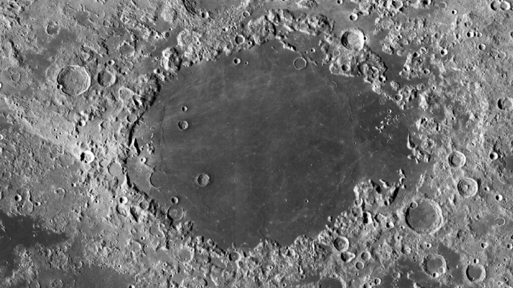
The maria and terrae can even be distinguished from Earth by the naked eye. The maria on the near side of the Moon appear to be dark and smooth, with only a few large craters. Some maria occur within the walls of large circular basins such as Crisium, Serenitatis, and Imbrium, whereas others such as Oceanus Procellarum occupy much larger, irregular depressions. We know from lunar rock specimens and surface features that the maria are vast layers of basaltic lava, which flowed into depressions and flooded large parts of the lunar surface.
Source: NASA / GSFC / Arizona State University
The terrae, or highlands, constitute about two-thirds of the near side of the Moon and exhibit a wide range of topographic relief. This is the highest and most rugged topography on the Moon, where local relief in many areas is up to 5000 meters. An important characteristic of the lunar highlands is that they contain abundant impact craters, many of which range from 50 to 1000 km in diameter. For example, craters larger than 10 km are about 50 times more abundant on the highlands than on the maria.
Source: Wikipedia
The far side of the Moon was totally unknown until photographs were first taken by the Soviet spacecraft Luna 3 in 1959. It was a total surprise to learn that, although the details were poorly defined, the far side of the Moon was composed almost entirely of densely cratered highlands. Later, orbiting satellites launched by the United States completely photographed the far side of the Moon with a definition sharp enough to map the surface in considerable detail. These photographs confirmed that the far side of the Moon is densely cratered; only a few large craters contain mare lavas. Why the maria are largely restricted to the near side of the Moon remains a fundamental question of lunar geology.
Results from several Apollo experiments demonstrate other fundamental differences between the highlands and the maria. Remote sensing measurements of the composition of the lunar surface indicate that the maria and highlands are composed of distinctly different rock types. Rocks collected by Apollo astronauts show the highlands to be mostly composed of anorthosite (i.e. type of intrusive igneous rock composed predominantly of calcium-rich plagioclase feldspar) and other feldspar-rich rocks (i.e. any of a group of aluminosilicate minerals that contain calcium, sodium, or potassium), in contrast to the basaltic maria. Tracking Moon-orbiting spacecraft from Earth has confirmed the elevation differences. The highlands may be as much as 5 km above the mean radius of the Moon, whereas the maria lie almost 5 km below the mean radius. The Moon has no large bodies of water, its mean radius can be used as a reference level from which relative elevations or depressions can be measured.
Gravity Recovery and Interior Laboratory (GRAIL) was a dual-spacecraft mission that involved placing two identical spacecraft in orbit around the Moon to use high-quality gravitational field mapping to determine its internal structure. The mission was the 11th in NASA’s Discovery Program. The GRAIL spacecraft revealed that the density of the lunar highland crust is substantially lower than generally assumed, which agrees with the data obtained during the final Apollo missions in the early 1970s. This suggests that the moon-rock samples brought back to Earth by the Apollo astronauts are characteristic of global rather than regional processes. GRAIL also found that the average thickness of the lunar crust is about 6 to 12 miles (10 to 20 km) thinner than previously thought – between 21 and 27 miles (34 and 43 km). The average density of the entire highlands crust is found to be 2550 kg m3, and individual density uncertainties are on average 18 kg m3. Significant lateral variations in crustal density exist with amplitudes of ±250 kg m3.
Results from the Gravity Recovery and Interior Laboratory (GRAIL) mission have shown that there is a major difference in the average thickness of the lunar crust between the nearside and the farside of the Moon. This nearside–farside crustal thickness difference is one of the fundamental characteristics of the Moon and is interpreted to explain its center of figure–center of mass offset. The origin of the nearside–farside crustal thickness difference has been attributed to:
(a) broad-scale convection patterns in the magma ocean,
(b) an excess of impact basins on the lunar nearside, and
(c) one or more extremely large impact basins.
Despite the seemingly geometric simplicity of the problem, the offset of the center of the Moon’s mass remains an unexplored problem in lunar science. The importance of this problem is that the Moon is close enough to the Earth and the accuracy of observations of its spin-orbital motion by the method LLR (Log Likelihood Ratio is a novel algorithm that enables us to evaluate the density of states in lattice gauge theory) is now so much high that for correct interpretation of these movements it is necessary to take into account many celestial mechanical disturbances, including the indicated internal asymmetry of the Moon’s body.
One of the manifestations of the offset center of mass can be a different thickness of crust in the near side and the far side of the Moon.
The maria and highlands not only represent different types of terrain, they broadly represent two different periods in the history of the Moon. The entire outer portion of the Moon is thought to have been molten at the time the highlands crust began to form 4.6 billion years ago. As light silicate minerals accumulated at the top of this “magma ocean,” they formed a crust, which soon became densely cratered by a contemporaneous intense bombardment of meteorites. This initial high cratering rate declined rapidly but the Moon’s surface, one of the oldest in the solar system, became covered with craters.
The maria were formed by the extrusion of vast amounts of lava that accumulated in the lowlands of large craters or basins and, in places, overflowed and spread over parts of the lunar highlands. The maria are thus relatively young features of the lunar surface, even though they began to form four billion years ago.
Advanced Lunar Geology Research
Nearly 300 years of geoscience on Earth has taught us the importance of understanding the geologic context of samples so as to best interpret the data we obtain from them in the laboratory. This is no less important on the Moon. In geosciences, the art and science of contextual awareness is the research domain of field geologists, and geologic fieldwork on the Moon is unusually difficult. No part of the ancient lunar surface is truly pristine; billions of years of space weathering, the combined effects of cosmic rays, solar wind, and meteorite bombardment complicate observable geologic relationships. Although the majority of meteorite impacts are small, large meteorite impacts can be problematic as they can result in a ballistic redistribution of material over great distances. These processes make it challenging to understand the geologic context of any sample collected without detailed geologic mapping. As is the case on Earth, remote-sensing data can help inform those mapping studies, similarly, the lunar geology starts with remote sensing datasets, topography, element maps derived from spectroscopy, images at various resolutions, etc., and geologic maps are made from these even before ever landing on the Moon. Extravehicular Activities and samples add context and those maps are continuously evolving and becoming more accurate.
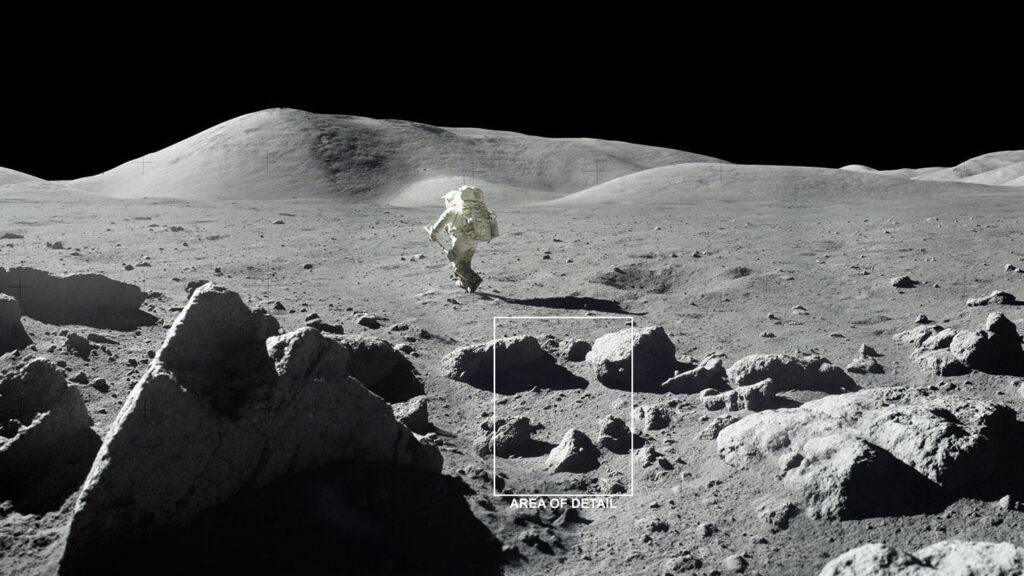
The need for geological training for astronauts was recognized at the beginning of the Apollo Moon missions in the 1960s. At that time each NASA astronaut went on at least 16 field trips and spent up to 300 hours in the classroom to prepare for each lunar geological mission goal. In future planetary missions, astronauts will probably explore complex environments such as lava tubes, canyon rills, and rough or icy surfaces. Training on Earth in places with similar geological features and operational conditions will help the astronauts to communicate effectively between themselves and the ground support during geological investigations in our Solar System.
The recognition and interpretation of geological structures and processes require experience, repeated encounters with the subject matter, and detailed field studies. The field training will teach astronauts decision-making methods and efficient documentation and descriptive techniques rather than wide and purely theoretical knowledge.
Geologic training must prepare astronauts to recognize geologic features and events, and to interpret, document, and report what they see from orbit to geologists on the ground. They also need to understand how remotely sensed data augment visual observations and relate to features that can be observed in the field. The astronauts familiarize themselves with geology, the trainees also learn to mimic how geologists think and work, it also trains the astronauts in collecting samples. It teaches how to do geology from a distance, whether that means from the space station or in preparation for landing on another planetary body. While small geologic features won’t necessarily be visible, there’s plenty of information that can be collected from a distance. The training also stretches beyond rocks and into topics like atmospheric science, oceanography, and land-use patterns to prepare astronauts for the full range of Earth-observation opportunities available from orbit.
Field geology was the single most emphasized type of scientific training for Apollo crews. Those realistic field exercises, amounting to many hundreds of hours and almost 25% of crew training time, were instigated and overseen by NASA’s Astronaut Office and implemented by a broad spectrum of professional geologists and engineers from the U.S. Geological Survey, academia, and NASA itself. The success of the Apollo training hinged on planning and debriefing by geologists who were field-oriented Earth scientists, not only planetary scientists, some of whom had decades of experience in both field research and teaching field geology in university settings. A similar emphasis on field geology training is required before we send astronauts to new targets for planetary exploration. In addition, including at least one classically trained field geologist as a crew member would maximize the quality and quantity of science that could be done.
Despite the value of training on Earth, field geology by humans on a planetary surface is very different from field geology as commonly practiced on Earth, and not only because of the constraints of space suits and time. Although terrestrial field geologists increasingly use drone imagery and data from handheld analytical instruments to improve their observations, enabling technologies (e.g., augmented reality, position tracking, and mobile robotics with varying levels of autonomy) are advancing rapidly and show great promise for advancing field geology on Earth. It seems obvious that the high stakes of planetary field geology would merit a major investment in the design of innovative field research strategies that incorporate emerging new technologies. International space agencies, however, are spending very small proportions of their budgets on field science operations research today. Most of the funding that is available is focused on analog testing of established technologies and traditional research strategies. With the next opportunities for lunar field science likely to be less than a decade away, the time is right for space agencies to support the establishment of multiple task forces – each including a broad spectrum of field scientists from academia, as well as the agencies themselves – to design a range of novel approaches to planetary field geology and to conduct extensive comparative experiments at complex terrestrial sites before incorporating any of them in mission planning and mission-specific training. Otherwise, we will have squandered an unparalleled opportunity to improve the geoscience we do on the Moon and – eventually – on Mars.
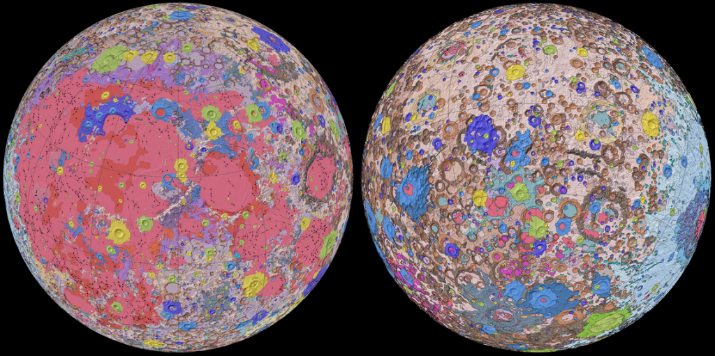
First-Ever Comprehensive Geologic Map of the Moon
The U.S. Geologic Survey (USGS) announced the new Unified Geologic Map of the Moon on April 20, 2020. This map shows the Moon’s surface geology, with rock layers and craters charted in great detail. As per USGS, it is designed to serve as the definitive blueprint for lunar science and future human missions to the Moon and to be used by the international scientific community, educators, and the public at large.
Credit: NASA/GSFC/USGS
To create the new digital map, scientists used information from six Apollo-era regional maps along with updated information from recent satellite missions to the Moon.
The existing historical maps were redrawn to align them with the modern data sets, thus preserving previous observations and interpretations. Along with merging new and old data, USGS researchers also developed a unified description of the stratigraphy (deals with the arrangement and succession of strata, or layers, as well as the origin, composition, and distribution of these geological strata), or rock layers, of the Moon. This resolved issues from previous maps where rock names, descriptions, and ages were sometimes inconsistent.
Credit: NASA/GSFC/USGS
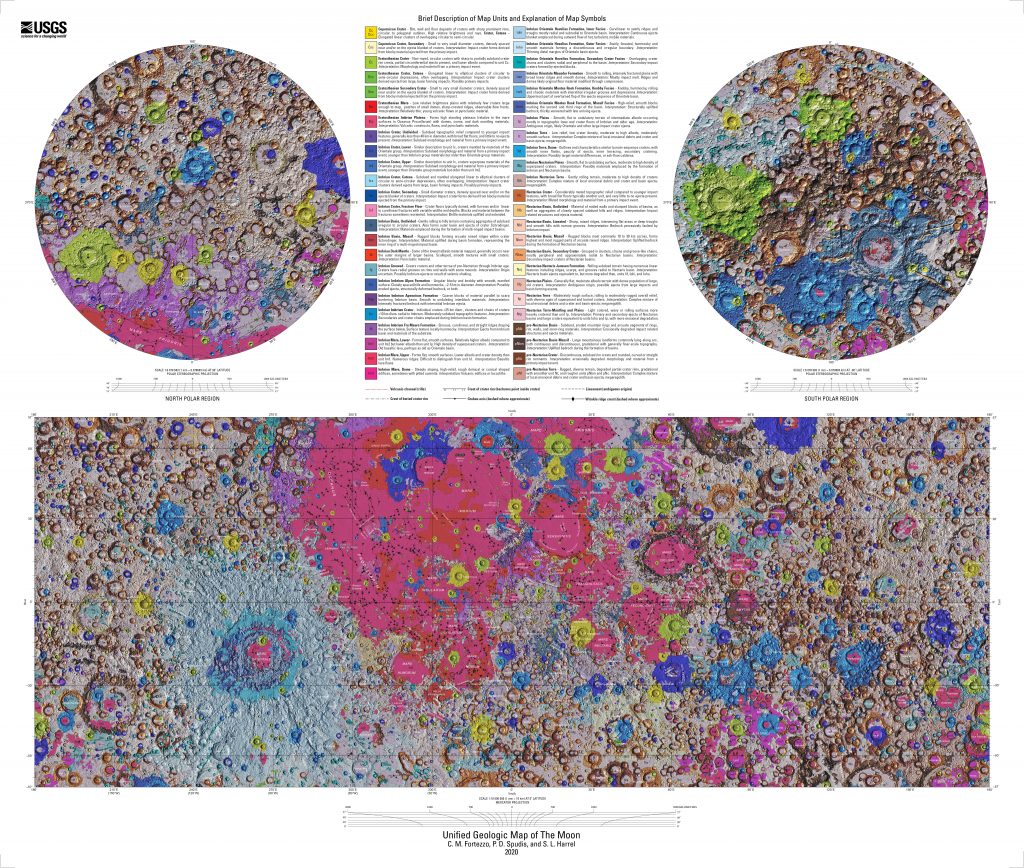
Topography for the north and south poles was supplemented with data from NASA’s Lunar Orbiter Laser Altimeter (LOLA), a robotic spacecraft currently orbiting the Moon. Data collected by the Lunar Reconnaissance Orbiter (LRO) have been described as essential for planning NASA’s future human and robotic missions to the Moon. Its detailed mapping program is identifying safe landing sites, locating potential resources on the Moon, characterizing the radiation environment, and demonstrating new technologies.
Elevation data for the Moon’s equatorial region came from stereo observations collected by the Terrain Camera on the SELENE (SELenological and ENgineering Explorer) mission led by JAXA, the Japan Aerospace Exploration Agency.
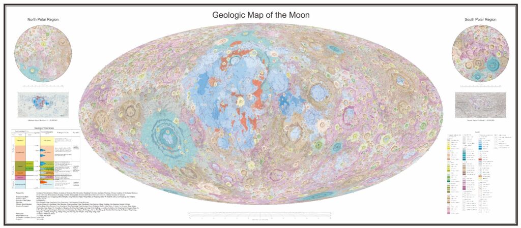
Second and the World’s Most Detailed Map of the Moon to Date
On May 30, 2022, Chinese scientists from the Institute of Geochemistry of the Chinese Academy of Sciences, among other Chinese institutions, have published the most detailed map of the Moon yet. It took them 10 years and involved hundreds of researchers. The new map shows 12,341 impact craters, 81 impact basins, 17 rock types and 14 types of structures, providing abundant information about geology of the Moon and its evolution. It is expected to make a great contribution to scientific research, exploration and landing site selection on the Moon. It is beneficial to lunar exploration and for anyone who just wants to study our natural satellite in more detail.
Up until 2022, the USGS map of the Moon with a resolution of 1:5,000,000 has been the standard. The new map is the first 1:2,500,000-scale lunar global geologic map, which incorporates the most comprehensive knowledge about the Moon by taking advantage of the latest exploration results and scientific findings. An updated lunar time scale is employed in this map to better reflect the dynamic evolution of the Moon. This geologic map provides a state-of-the-art illustration of impact basins and craters of different periods, the distributions of 17 types of rocks and 14 types of structures.
Source: ScienceDB
The map uses a Mollweide projection that creates an elliptical view of the Moon. China also provided stereographic projections, separately centered on the north and south poles.
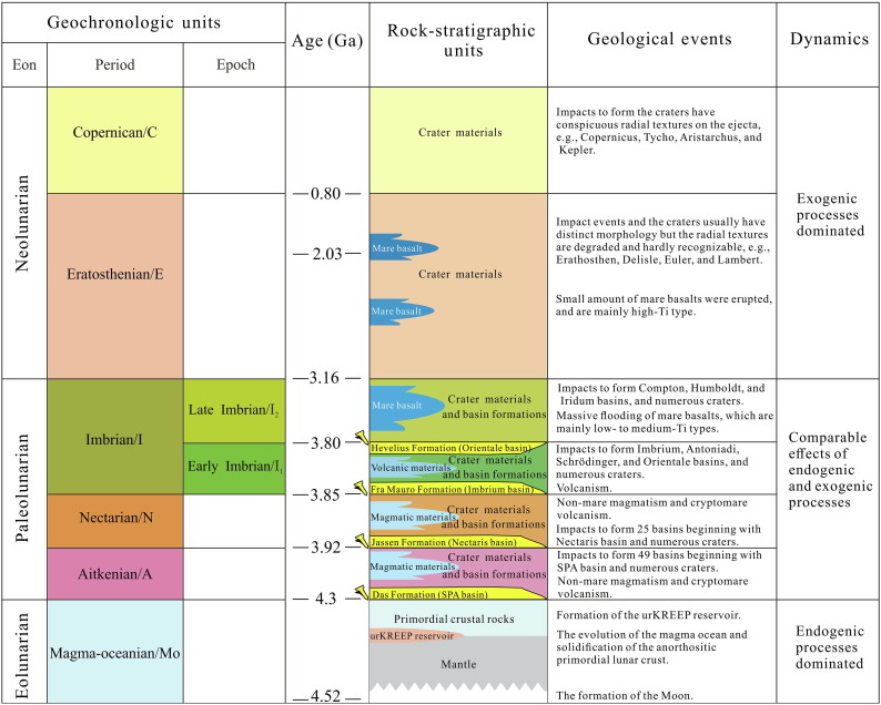
The geologic time scale, which categorizes geologic units into different chronologic periods with respect to the most significant evolutionary events, is the foundation for a geologic map. The current lunar time scale was proposed in 1987 by Don E. Wilhelms, John F. McCauley, and Newell J. Trask, while the past decades have seen great progress in studying the geological evolution of the Moon.
Only by small modifications, the updated lunar time scale scheme shows great advantage in highlighting the dynamic evolution of the Moon, which is important for revealing the evolution history from geologic maps.
Source: The 1:2,500,000-scale geologic map of the global Moon
These orbiting, landing, and roving Chinese missions collect diverse datasets that enable integrated research on lunar surface materials, improve our understanding of lunar magmatic evolution, and provide primary sources for this lithological mapping effort.
The remote sensing datasets were compiled and integrated using Geographic Information System (GIS) software to build a unified database of lunar lithologic distribution, on which subsequent lunar geologic mapping and review of lunar geologic history were based.
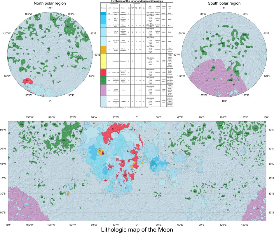
Source: Digital and global lithologic mapping of the Moon at a 1:2,500,000 scale
The lithologic map of the Moon was prepared based on visible and near-infrared, X-ray, and gamma ray spectroscopic datasets of the Chang’e missions.
The new lunar map can be used for further lunar geologic mapping and scientific research, exploration planning, sampling and selection of return landing sites. It can also provide a reference for mapping other Earth-like planets in the future.
In-Situ Resource Utilization (ISRU)
On the Moon, large amounts of various resources have already been discovered, starting with gases, water, minerals, and ending with metals. For example, huge amounts of such an isotope as helium-3 (a light, stable isotope of helium with two protons and one neutron) were found there. It is potentially interesting to use as a fuel in nuclear fusion. Modern atomic reactors use atomic decay energy, whereas, in nuclear synthesis, hydrogen atoms combine to form helium. This reaction releases a large amount of energy. Since the atmosphere on the Moon is absent, it means that its surface was bombarded by charged particles for billions of years, and a significant part of them could penetrate into such a surface. These particles could also be helium-3, which could possibly be extracted by heating the lunar rock and then collecting the produced gas. The global inventory of 3He was estimated as being 6.6 × 10⁸ kg, in which 3.7 × 10⁸ kg was estimated for the lunar nearside and 2.9 × 10⁸ kg was estimated for the lunar far side.
Water is another type of potentially important resource. After all, it is necessary to provide water for each of the subsequent missions to deep space. Thorough studies show the presence of billions of tons of water ice on the Moon, both in the near-polar craters, where temperatures can drop to 50 K, and on the rest of the surface at a certain depth. This water is in the permanently shadowed regions in those polar craters, these areas never get sunlight, keeping the water trapped.
It is there that the water ice is supposed to be melted and then the resulting water must be cleaned. Further, water can be converted to O2 and to hydrogen peroxide (H2O2 the chemical compound H2O2, made up of two hydrogen atoms and two oxygen atoms); after that, these gases should be condensed into liquid oxygen, hydrogen, and hydrogen peroxide. These chemicals are a potential type of rocket fuel. That is, the extracted water can be used to turn into rocket fuel while providing communication on the lower part of the near-Earth orbit, conducting space tourism, removing space debris, and ensuring human activity on the Moon and in more remote areas of space. Also, unmanned all-terrain vehicles can be delivered to the Moon in order to explore possible water deposits. Full mining of existing minerals on our satellite will become a reality only after the creation of a permanent special base on the surface, or beneath.
Lunar Meteorites (Achondrites)
Since meteorites formed through a variety of processes on many different planetary bodies, they can have substantially different physical and chemical properties. Some meteorites, particularly primitive chondrites, are quite unlike any other type of rock found on Earth and can be readily identified. However, other meteorites, particularly achondrites, were produced by the same types of igneous processes that occur on Earth and may be very difficult to recognize.
Achondrites are the most difficult specimens to differentiate from terrestrial rocks because they formed on bodies where the same processes that operate on Earth occurred. Consequently, their mineral assemblages (i.e. the minerals that compose a rock, including the different kinds and their relative abundance), densities, and textures are similar to those of terrestrial rocks. An intact fusion crust is the best criterion for identifying candidates for future studies. Some achondrites are breccias and thus their interiors may consist of a mixture of light and dark angular clasts. A related group of achondrites, called mesosiderites, are brecciated (i.e. broken down into angular fragments; breccia is a rock composed of large angular broken fragments of minerals or rocks cemented together by a fine-grained matrix) and metamorphosed (i.e. subjected to metamorphism; metamorphism is the transformation of existing rock to rock with a different mineral composition or texture). This latter group of meteorites is often lumped with pallasites as stony-iron meteorites because the metal in them coagulated (i.e. changed to a solid state) into large silvery blebs (i.e. a small bubble-like inclusion of one mineral within a larger mineral; meaning the inclusion of a mineral within a larger mineral that is bubble-like) in an otherwise gray to brown silicate interior.
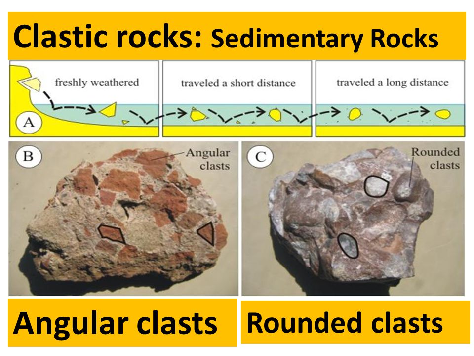
Source: Shape of Particles Angular Sub-rounded Well-rounded
The current practice is to divide the achondrites into two broad categories – differentiated achondrites and primitive achondrites. The former generally have igneous textures (include the rock textures occurring in igneous rocks; reveal how a rock formed) and compositions far removed from those of nebular materials, while the latter have metamorphic textures (i.e. description of the shape and orientation of mineral grains in a metamorphic rock; metamorphic rock textures are foliated, non-foliated, or lineated) and compositions less distinct from those of nebular materials.
- Differentiated achondrites. They are achondrites that exhibit igneous textures or igneous textures modified by impact and/or thermal metamorphism, and that have compositions of lithophile (i.e. elements that are preferentially partitioned into silicate minerals as opposed to sulfides or metals), siderophile, chalcophile, and atmophile elements that are highly fractionated from the ranges of chondritic materials (i.e. stony, non-metallic, meteorites that have not been modified, by either melting or differentiation of the parent body).
- Primitive achondrites. They are achondrites that exhibit equilibrated, metamorphic textures, possibly modified by impact. Rare members have relict (also palimpsest textures; textures inherited from the original rock type, and which have survived metamorphism) chondritic textures, but examples with classic, unequilibrated chondritic (i.e. type 3, called unequilibrated ordinary chondrites; type 3 chondrites show low degrees of metamorphism) textures are absent. They have compositions of lithophile, siderophile, chalcophile, and atmophile elements that are at most only moderately fractionated from the range of nebular materials. Some members may be quite fractionated, but the group as a whole is dominated by primitive materials.
Lunar Meteorite Clan
Lunar meteorites are classified by their texture, petrology, and chemistry. They include a wide range of rock types including brecciated (i.e. formed or broken into breccia, broken down into angular fragments over two millimeters in diameter) and unbrecciated mare basalts, mixed mare/highlands breccias, highland regolith breccias, and highland impact-melt breccias. The lunar meteorites share many common mineralogical (e.g. Fe/Mn ratios in pyroxenes), bulk chemical, and O-isotopic (Oxygen-Isotopic) compositions with the Apollo and Luna samples.
The Moon is composed of two basic igneous landforms: the lunar highlands and the lowland maria which include the impact basins. The majority of lunar rocks found both on the Moon and on Earth are anorthositic (anorthosite is the type of intrusive igneous rock composed predominantly of calcium-rich plagioclase feldspar). They are highland rocks. They are primarily monomineralic (i.e. composed of a single mineral) igneous (i.e. having solidified from lava or magma) rocks, composed mainly of anorthite, a calcium-plagioclase mineral, rich in aluminum and poor in iron. On the Moon, the highland rocks are 75–80% regolith breccias.
Given the Moon’s history of impact events, it is no surprise that most of the lunar rocks are breccias. Nor should it surprise us to learn that many breccias contain fragments of both highland anorthositic rocks and mare basalts. This newly recognized group of meteorites contains 11 lunar breccias classed as mingled breccias, including the famous Calcalong Creek. It is composed of 50% anorthosite and 35% basalt and other maria minerals and can be seen as a transition between the two types. Calcalong Creek is comprised mainly of dark glassy matrix, but contains a variety of clast types and mineral fragments, dominated by highlands lithologies, such as anorthosites, gabbroic anorthosite (i.e., with plagioclase 75–90% of the rock), spinel troctolite, and KREEP basalt.
Like the Lunar rocks, Lunaites provide valuable information about the chemical and mineralogical complexity that can be found on the surface of the Moon. Despite that we don’t know exactly their origin on the Lunar surface, these relatively small rocks provide clues to the processes going on in the surface of the Moon. Carbon and other organic compounds are also common in regolith-rich regions of the Moon. There is a dominant flux of CM chondrites that after impact dehydrate and end up as “graphitized” (i.e. converted into graphite) clasts observed in regolith breccias. Furthermore, it has been theorized of an uncertain amount of hydrocarbons (i.e. an organic chemical compound that is composed exclusively of hydrogen and carbon atoms) could be used for the production of complex polymers, resins, and plastics.
Lunar meteorites are valuable samples teaching us about the processes going on over the Moon, at the same time they provide clues on the most important minerals for mining. Many different initiatives on how to tackle Lunar resources are taking place: from 3D printers that previously construct the necessary infrastructure for lunar mining, the utilization of autonomous robots, and obviously, the mingling of different proposals according to the exploitation stage. The Lunar surface provides a lot of valuable materials, but precise know-how is required to successfully exploit them. Then, a careful study of Lunar samples and meteorites will provide significant progress in optimizing ISRU.
Rare-Earth Elements (REEs)
The Rare-Earth Elements (REEs) are a group of transition metals that include the lanthanide series of the periodic table (lanthanum (La) to lutetium (Lu)), in addition to scandium (Sc) and yttrium (Y). Despite the nomenclature, they are not rare with cerium (Ce) being the 25th most abundant element on Earth at an average value of 60 ppm (ppm means “parts per million” and it also can be expressed as milligrams per liter (mg/L); usually describes the concentration of something in water or soil).
Source: etech-resources
The REEs are widely used on Earth by humankind on a daily basis. They are integral components of smartphones, computer monitors, flash drives, lightbulbs, camera lenses, catalysts, and magnets, and are fundamental to many military-based technologies. The REEs are also a critical material in clean energy technologies and within major areas of utility including wind turbines, lighting, magnets, and vehicles. Several industry sectors are heavily dependent on REEs owing to their magnetic, electrical, and optical properties. These industry sectors include but are not limited to defense, power generation, energy efficiency, catalysis, and medicine.
KREEP is an acronym used in geochemistry to represent a mixture of K-potassium, REE-rare earth elements, and P-phosphorus. The Apollo astronauts collected lots of samples of rocks and dust, and KREEP-rich materials were returned from every one of the landing sites. Geologists concluded that KREEP-rich late melt was present all over the Moon.
Thorium Abundance
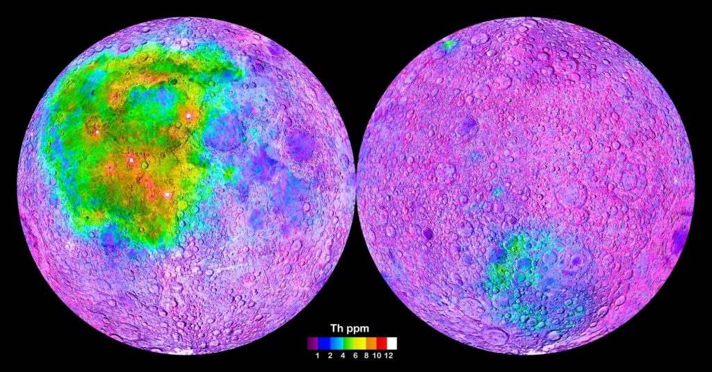
On Earth, thorium (Th) is chiefly refined from monazite sands as a by-product of extracting rare-earth metals and is estimated to be over three times as abundant as uranium in the Earth’s crust. Thorium has a electromagnetic signature that makes it easy to find even from a spacecraft. The below map of the Moon reports a global map of the thorium distribution on the lunar surface, generated from gamma-spectrometric data collected by the Lunar Prospector Orbiter.
Source: NASA
The map shows the global distribution of the element Thorium in surface rocks, with high Thorium concentrations indicating the occurence of the KREEP rocks, which have high contents in Potassium, Rare Earth Elements and Phosphorus. The heterogeneous distribution of KREEP rocks at the Moon’s surface implies fundamentally different geological histories of the individual lunar regions (terranes).
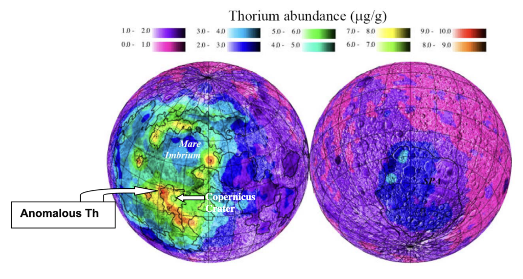
Thorium (Th) distribution map of the lunar nearside (left) and farside (right), mapped by the Lunar Prospector. Thorium correlates with the location of KREEP.
Source: NASA
The thorium distribution on the lunar surface is important for distinguishing among different lunar lithologies (i.e. the composition or type of rock; study of rocks and their formation) and terranes (i.e. a group of related rocks that formed together in one area, do not show any relationship to the other rocks around them, and are separated from the rocks around them by faults), acts as a key proxy of lunar crustal thickness, provides a significant indication of lunar chemical heterogeneity, and suggests an important clue for reconstructing Lunar Magma Ocean (LMO is the layer of molten rock that is theorized to have been present on the surface of the Moon) crystallization. Therefore, lunar surface thorium is a pivotal vehicle to explore lunar evolutionary history.
Robots for Geological Exploration
These robotic vehicles provided scientists and engineers with a greater understanding of interplanetary space and lunar geography and played an important role in preparing for a manned landing. On the plus side, humans in space provide operational flexibility, inspiration, and native intelligence. On the minus side, that flexibility comes at a steep price. Humans are heavy, fragile, dirty, vulnerable, picky about their environment, and have a low tolerance for the space environment (i.e., high energy radiation, extreme heat and cold, etc.). The fragility of humans, our aversion to risking human life, and the all-too-human need for consumables (food, water, and oxygen) require vast amounts of money to pay for the extra engineering and multiple redundant systems. It demands to reduce the risk to astronauts, as well as for the vastly larger support crews needed to taking care of every aspect of daily life during a manned space mission. Robotic exploration is necessary to enable human exploration by setting the context, providing critical information, and reducing the risk to humans.
The Volatiles Investigating Polar Exploration Rover (VIPER), is a lunar volatiles (i.e. the group of chemical elements and chemical compounds that can be readily vaporized) detection and measurement mission that will be launched as a payload on the CLPS (Commercial Lunar Payload Services) provided by Astrobotic’s Griffin lander to the lunar south pole. VIPER has two primary objectives:
- Characterize the distribution and physical state of lunar polar water and other volatiles in lunar cold traps and regolith to understand their origin.
- Provide the data necessary for NASA to evaluate the potential return of In-Situ Resource Utilization (ISRU) from the lunar polar regions.
Lunar Trailblazer, a mission selected under NASA’s Small Innovative Missions for Planetary Exploration (SIMPLEx) program, carries two instruments to achieve its science objectives: the High-resolution Volatiles and Minerals Moon Mapper (HVM3) from JPL, and the Lunar Thermal Mapper (LTM) from the University of Oxford. When used in conjunction, these two instruments provide the ability to simultaneously identify the various forms of water on the Moon, as well as mineralogy and temperature. Lunar Trailblazer has four primary objectives:
- Determine the form, abundance, and distribution of H2O and OH in sunlit terrains;
- Assess time variability of lunar volatiles;
- Determine the form and abundance of ice, bound H2O, and OH in permanently shadowed regions (PSRs); and
- Understand how localized gradients in albedo and surface temperature affect ice and OH/H2O concentration.
A robotic platform could also provide capabilities that improve astronaut safety and aid in mission planning. For example, an array of guidance sensors mounted on a 2-degree-of-freedom (pan/tilt) sensor mast could provide navigation, route-planning, and hazard-detection capability. Examples of these sensors include an Integrated Vision System (IVS) with stereoscopic cameras and LiDAR. This hardware is a prototype stand-off instrument that would be mounted on a rover mast for planetary exploration and would allow the robotic platform to function as a stable and mobile ‘camera crew’, freeing the astronauts to carry out tasks other than mission documentation. In combination with a communications antenna uplink to the Gateway (a planned small space station in lunar orbit intended to serve as a solar-powered communication hub, science laboratory, short-term habitation module for government-agency astronauts, as well as a holding area for rovers and other robots), the visual cameras on the rover could be used to stream footage of humans investigating previously-unexplored regions of the Moon (including the far side) to Earth in near real-time.
Planetary Geology
Studies of planetary geology can greatly help us to understand how the planets and moons of the solar system were formed, and how their current surfaces came to be. Analyses of rocks, either in-situ or brought to Earth via meteorites or space missions can help determine the composition of the planet or moon as a whole and from this infer the composition of the material from which those bodies were originally formed. Studies of the geology of other planetary bodies largely rely on studies of the geology of our own planet. However, there are major differences. The Earth’s surface is largely dominated by plate tectonics, in which large plates of the crust move and create mountain chains (where plates collide), subduction zones (where one plate dives under another), and spreading ridges (where plates are moving apart). No other body in the solar system is known to have plate tectonics.
One consequence of plate tectonics is the destruction of the old crust. If we compare the Earth’s surface with, for example, the Moon’s, we immediately see that much of the Moon’s surface is covered by impact craters, while few impact craters can still be found on the Earth. Other than plate tectonics, the other destructive process on Earth is erosion. The Earth is the only planet with the right combination of atmospheric surface pressure and temperature to allow liquid water to exist and to cover such a large fraction (~70%) of the surface. Impact craters are erased relatively rapidly on Earth by the action of plate tectonics and erosion due to weather, as well as volcanism. The Earth’s atmosphere does offer our planet some protection from small meteorite impacts and, for this reason alone, would have a different crater size and frequency distribution from that of an airless body.
The Terrestrial Planets
The planets of the solar system can be divided into two major compositional groups. The four smaller inner system planets, Mercury, Venus, Earth, and Mars are known as the terrestrial (Earth-like) planets and are characterized by silicate compositions and iron cores. The four outer system planets are hydrogen-rich giant planets, being substantially more massive than the terrestrials. Terrestrial planets formed much closer to the Sun than the outer planets, in the part of the solar nebula (i.e. gaseous cloud from which, in the so-called nebular hypothesis of the origin of the solar system, the Sun and planets formed by condensation) which was too warm for ices to condense. The terrestrial planets all have solid surfaces where the major geologic processes have operated. Mercury is heavily cratered, its proximity to the Sun allows for impactors to have high encounter velocities. The lack of any significant atmosphere on Mercury also means that not only it does not have any protection from oncoming objects, but also it has had no erosion by weather. Similarly, the lack of plate tectonics means that the old crust was largely preserved. If we consider impact craters, knowing that the oldest surfaces of the solar system will have the largest impact scars and the largest numbers of craters, then next to Mercury is Mars, with also a considerable number of craters, largely because of its proximity to the asteroid belt.
However, the surface of Mars shows considerable signs of active geology such as volcanism, tectonism, and erosion. The surface of Venus has fewer impact craters than Mercury or Mars and is dominated by volcanism. The dense Venusian atmosphere (the atmosphere at the surface is ~65 kg/m^3 with a surface pressure of 94 bar; for comparison, water is 1000 kg/m^3) is capable of protecting the surface from some impactors, which break up in the atmosphere. Also, volcanic activity has resurfaced large areas of the planet, erasing the evidence of craters. The small number of impact craters recognized on the Earth’s surface or in the oceans attest to how geologically young the surface of our planet is.
Mercury
Mercury is a very dense body due to its large iron core, which is estimated to be 2,020 km in radius. Mercury’s surface is somewhat similar to that of the Moon and impacts cratering has been a major process. Mercury has heavily cratered highlands and large areas of younger smooth plains that surround and fill impact basins. Like the Moon, the surface of Mercury has a layer of regolith formed by many impacts. The volcanic areas are flooded plains similar to the lunar maria. In addition, there are tectonic features, though Mercury, like all other planets except the Earth, has no plate tectonics. The exploration of Mercury by spacecraft started in the 1970s with the NASA’s Mariner 10 mission. It would be decades before the next mission, NASA’s MESSENGER, went back to the planet to make significant new discoveries.
Venus
Venus is similar to Earth in terms of size and density, but very different in terms of atmospheric conditions and geologic evolution. The surface of Venus is dominated by plains (i.e. a flat expanse of land that generally does not change much in elevation; form in many different ways including from flowing lava), which cover at least 80% of the planet. There are also major highlands, including plateaus (i.e. areas of fairly level high ground) and topographic rises, and ridges (i.e. elevated body parts or structures) and rifts (i.e. breaks in the crust created by it spreading or splitting apart). Venus has few impact craters (~940 identified), indicating that its surface is young. On average, it is comparable to the surfaces of the Earth and Titan.
Mars
The surface of Mars is more Earth-like than that of any other body except for Titan. Mars presents remnants of all the major geologic processes. Volcanism has been an important part of geologic history. Mars has the largest shield volcanoes in the solar system, vast plains of lava flows, many lava channels (i.e. narrow, curved or straight open pathways through which lava moves on the surface of a volcano), domes (also called volcanic dome, steep-sided mound that is formed when lava reaching the surface is so viscous that it cannot flow away readily and accumulates around the vent), and cones (i.e. the triangle-shaped hill formed as material from volcanic eruptions piles up around the volcanic vent, or opening in the planet’s crust), and it has evidence of explosive volcanism and extensive pyroclastic (i.e. clastic rocks composed solely or primarily of volcanic materials) deposits. Because Mars has been the primary focus of planetary exploration since the mid-1990s, and because it has been visited by several spacecraft including orbiters, landers, and rovers, there is a vast quantity of data available on Martian surface geology, including images at resolutions from 30 cm/pixel to several km/pixel, as well as data on surface compositions and the role of volatiles, and atmospheric dynamics and composition, though the composition and nature of the Martian interior have not been well investigated. Rovers have returned field geologists’ views of several areas on the surface.
A major feature of Martian geology is the hemispheric dichotomy (i.e. the oldest and largest geologic feature on Mars): about one-third of the planet’s surface (mostly in the northern hemisphere) lies 3–6 km lower in elevation than the southern two-thirds. The dichotomy is also seen as a difference in impact crater density and crustal thickness between the two hemispheres.
Economic Geology of Lunar Resources
Economic planetary science is a young discipline set to expand rapidly with the potential to become a primary driver of science in this century. Similar to economic geology on Earth, economic planetary science is concerned with utilizing resources in space for economic and industrial activity. Science is produced only as a byproduct (either incidentally or to support business decisions), but experience shows it can exceed the science produced intentionally by government investment. Commercial companies are beginning new activities in space and some national governments are setting policies to encourage them.
The trends that have made this possible are the maturity of rocket technology leading to lower launch costs, autonomous robotics, and the overall growth of Earth’s economy and supply chain enabling an ever-widening range of activities. Supporting government-led space exploration has long been an economic pursuit of commercial companies.
The best known of the new activities is asteroid mining to produce rocket propellant for purely commercial uses such as boosting telecommunications satellites into their final orbits. Commercial companies are also pursuing the in-space manufacture of large antennas to keep up with Internet growth, beaming microwave energy to Earth to replace carbon-based energy more affordably than ground-based renewables, space tourism including lunar landings, and providing services and material to anyone attempting settlement. While some of these may seem fanciful, some already have reasonable business cases while the expanding space and terrestrial economies suggest the others may get there soon.
Economic analysis of lunar resource use is centered chiefly on rocket fuel, which would be the major use for lunar materials, and secondarily on life support. Parametric studies based on estimates of demand, transportation factors, and manufacturing cost, indicate that the cost of interplanetary missions can be reduced by factors of 4 to 10 with the use of lunar and planetary resources. Human factors discussed include requirements and the efficiency of resupply, regeneration, and synthesis of life support supplies (air, water, and food). Long-term bases, spacesuit design, water recovery, metabolic loads, and time allocation. Synthesis of these from lunar materials becomes attractive for further research.
Lunar resources include indigenous energy and materials which can be profitably used. The chief lunar energy source is solar radiation; in addition, geothermal steam (called selenothermal energy, i.e. using heat of Moon’s core), if available, and thermoelectric system to generate electricity from the extreme heat of the lunar environment, in a simple way that has no moving parts, in particular, thermocouples where heat from the components is converted into electrical power by thermocouples would be valuable. There is enough of a temperature difference to be useful, whether you’re producing electricity via a thermocouple, utilizing excess heat to help keep spacecraft subsystems warm during the lunar night, or just working to keep the lunar base at a comfortable temperature.
Material resources, for life support, structural purposes, and rocket fuel, which can be expected to exist on the Moon include hydrogen, oxygen, silicon, iron, magnesium, calcium, aluminum, manganese, and titanium are some of the metals and minerals on the Moon.
Interestingly, oxygen is the most abundant element on the Moon. It’s a primary component found in rocks, and this oxygen can be converted to a breathable gas with current technology. A more practical question would be how to best power this process.
Lunar soil is the easiest to mine, it can provide protection from radiation and meteoroids as material for construction. Ice can provide water for radiation shielding, life support, oxygen, and rocket propellant feedstock. Compounds from permanently shadowed craters could provide methane, ammonia, carbon dioxide, and carbon monoxide. This is just the beginning – as more missions are sent to the Moon, there is more to discover.
Concluding Remarks
The Moon represents the fundamental underpinnings for understanding solar system processes and history. The Moon is also a critical enabling asset for any human exploration activity that the world may undertake in space, now and in the future. By creating the capabilities inherent in executing the Lunar Exploration Roadmap will enable us to go anywhere, and do things heretofore only imagined, throughout the solar system.
Building cislunar infrastructure does not require technologies wildly outside our experience base. Rather, it is facilitated with evolved versions of currently existing technologies, such as microwave power transmission, laser communications, solar power, nuclear fission power, regenerative life support, propellant transfer and storage, and telerobotics. In terms of new investments, the demonstration and flight qualification of presently well-conceptualized (but unflown) technologies for cislunar resource extraction and utilization would provide a capability required for any future sustained human space operations. Project Artemis of NASA is taking some of the first steps towards a sustainable human presence at the South Pole of the Moon.
With its easy access to benign illumination conditions and proximity to potentially economic volatile reserves the South Pole of the Moon is the place where we will convert space from a wilderness, visited only briefly and tentatively, to a sustainable frontier of human activity where we answer fundamental scientific questions, grow a cislunar economy, and pave the way to journeys beyond.